UAV Services
UAV Services
Our drone-based inspection and mapping services include:
Real-time aerial inspections and monitoring
Live video feed for remote inspection and coordination
Real-time project tracking via field collection apps
GIS-integrated support for field operations
Drone LiDAR scanning and terrain modeling
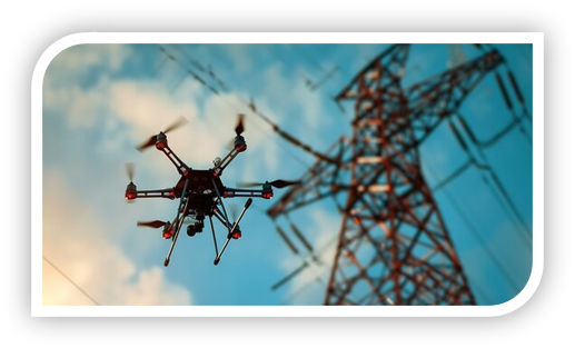
Utility asset condition evaluations (poles, towers, insulators)
Vegetation encroachment and wildfire risk analysis
Conductor clearance and sag verification
Thermal imaging for hot spot detection and equipment health
Aerial LiDAR surveying and point cloud generation
Digital orthophotography (RGB and multispectral)
Volume calculations and surface modeling (e.g., stockpiles, grading)
3D video fly-throughs and 3D PDF deliverables
Geophysical and magnetic imaging
Corridor mapping for transmission and pipeline routes
Environmental and land use impact assessments
Construction progress documentation and verification
Post-storm or post-disaster damage assessments
UAV Services
At Magna Consulting & Design, we deliver safe, efficient, and data-rich UAV (drone) inspection and mapping services tailored to utility, infrastructure, and construction projects. Our FAA Part 107-certified pilots operate unmanned aerial systems equipped with advanced LiDAR sensors and high-resolution cameras to capture precise, actionable data across large or hard-to-reach areas.
We support asset inspections, vegetation management, clearance analysis, and terrain modeling with real-time aerial insights. Our team provides live video feeds, real-time project tracking, and seamless GIS integration to enhance situational awareness, reduce field time, and improve safety and efficiency in the field.
From 3D visualizations and point cloud generation to orthomosaic mapping and volumetric analysis, our certified aerial teams help clients plan, validate, and maintain critical infrastructure with accuracy, speed, and confidence.
